


Sediment-laden water leads to water quality degradation in streams; therefore, best management practices must be implemented in the source area to control nonpoint source pollution. Field monitoring was implemented to measure precipitation, direct runoff, and sediment concentrations at a control plot and straw-applied plot to examine the effect on sediment reduction in this study. A hydrology model, which employs Curve Number (CN) to estimate direct runoff and the Universal Soil Loss Equation to estimate soil loss, was selected. Twenty-five storm events from October 2010 to July 2012 were observed at the control plot, and 14 storm events from April 2011 to July 2011 at the straw-applied plot. CN was calibrated for direct runoff, and the Nash-Sutcliffe efficiency and coefficient of determination were 0.66 and 0.68 at the control plot. Direct runoff at the straw-applied plot was calibrated using the percentage direct runoff reduction. The estimated reduction in sediment load by direct runoff reduction calibration alone was acceptable. Therefore, direct runoff-sediment load behaviors in a hydrology model should be considered to estimate sediment load and the reduction thereof.
토양유실은 유역 내 산림, 도시, 농경지 등에서 발생할 수 있는 자연적인 현상이다. 그러나 농경지에서 유실된 토양이 하천으로 유입될 경우 수질을 악화시킬 수 있다(Park et al., 2007; Park et al., 2014). 특히 밭 지역에서 발생하는 토양유실은 토양의 특성, 재배작물, 재배방법, 경사도, 경사장, 비료 및 농약의 사용량, 강우량 등에 따라 적지 않은 영향을 받는다(Carey et al., 2011; Coulter et al., 2004).
농경지에서의 비점오염원을 제어하고 관리하기 위한 최적관리기법에 대한 연구가 진행되고 있으며, 특히 지표를 피복함으로써 토양유실을 방지하는 방법도 제안되고 있다. 강우 시에는 빗방울의 타격에 의해서 지표의 토양입자가 이탈하게 되고, 이탈된 토양입자가 지표유출수에 의해 이동하게 된다. 그러나 지표를 피복할 경우 피복재에 의해 빗방울의 타격에 의한 토양입자의 이탈을 줄일 뿐만 아니라, 토양층으로의 침투량이 증가한다. Choi et al. (2000)은 3년 동안의 유사량 모니터링 자료를 통해서 농경지에서의 토양유실량을 최소화하기 위한 최적관리기법을 경운방법, 지표피복, 시비방법에 의해 평가하였다. 이로써 경사가 급한 고랭지에 위치한 농경지에 대해서 무경운 영농, 지표피복, 고랑격벽의 설치를 통해 이랑붕괴의 최소화, 승수로의 설치, 완충지의 설치, 동상방지방법의 개발, 겨울작물의 재배 등을 제안한 바 있다. Shin et al. (2009)은 실내인공강우시험을 통해서 강우강도, 경사도, 지표피복에 의한 직접유출량, 기저유출량, 토양저류량을 측정하였다. 그리고 볏짚으로 지표를 피복할 경우 강우 시 토양유실 제어에 효과적이었을 뿐만 아니라, 탁수 발생량에도 적지 않은 영향을 주는 것으로 보고한 바 있다. Shin et al. (2013)은 토양개량제인 Gypsum과 Polyacrylamide(PAM)을 볏짚 거적과 함께 농경지에 적용하였는데, Gypsum과 볏짚거적을 적용하였을 때는 유출량이 60.8% 감소하고, PAM과 볏짚거적을 적용하였을 때에는 유출량이 96.7% 감소하였다고 보고한 바 있다. Park et al. (2014)은 CN과 USLE 기반의 모형을 이용하여 최적관리기법을 모의하였는데, 도시지역에 비해 농경지에 대한 최적관리기법들이 경제적이라고 보고한 바 있다.
최적관리기법에 의한 비점오염원의 거동을 이해하기 위해서는, 시험포나 경작지에서의 모니터링이 이루어질 필요가 있다. 또한 시험포나 경작지에서 평가된 최적관리기법에 의한 비점오염원의 저감 효과는 다른 지점이나 유역에 적용하기 위해서나 혹은 유역 단위에서의 저감 효과를 분석하기 위해서는 최적관리기법에 의한 비점오염원의 정량화가 필요하다(Jang et al., 2010; Lee et al., 2014).
볏짚에 의한 지표피복 등과 같은 최적관리기법에 대한 평가를 위해서는 모니터링뿐만 아니라, 수문 모형에 의한 평가도 필요하다(Bishop et al., 2005; Jang et al., 2010; Kim et al., 2006; Lee et al., 2014; Lee et al., 2012; Lee et al., 2000; Maringanti et al., 2009; Maringanti et al., 2008; Park et al., 2014; Srivastava et al., 2002)
Jang et al. (2010)은 Curve Number (CN)를 이용하여 유출량을 모의하며, 유역 단위 모형인 Soil and Water Assessment Tool(SWAT; Arnold et al., 1998)과 시험포 단위 모형인 VFSMOD-w (Muñoz-Carpena et al., 1999)를 이용하여 유역에서의 볏짚매트에 의한 토양유실 저감 효과를 분석하였다. 30 mm/hr와 60 mm/hr의 인공강우와 1 m × 1 m × 0.65 m 크기의 토양상자에서 5%, 10%, 20%의 경사도에 따른 유사량을 측정한 후, 시험포 단위 모형인 VFSMOD-w 모형을 이용하여 범용토양유실공식의 경작방법인자(USLE P factor)를 추정하였다(식 (1)). 실측 유사량에 대한 모의 유사량의 결정계수(Coefficient of Determination, R2)가 0.91로 나타났으며, USLE P 인자를 추정하기 위한 회귀식(식 (1))과 수문 모형을 통한 볏짚매트에 의한 유사량 저감 모의 방법을 제안한 바 있다(Jang et al., 2010). 그러나, 볏짚매트가 현장에 설치될 때에는 지표를 피복함으로써 표토의 교란을 막기 때문에 침투량이 증가하며, 감소된 지표유출에 의한 토양 유실이 저감되나 이에 대한 과정이 고려가 되지 않았다. 즉 유출량과 유사량의 관계나 유출량의 변화에 대한 고려가 수문 모형의 이용과정에서 이루어지지 않았다.

여기서,
Lee et al. (2014)은 SWAT 모형에 대해 USLE P 인자를 통해서 식생매트 투수롤, 다발형 식생수로관, 플륨관, 투수롤과 같은 4개의 최적관리기법에 의한 유역에서의 토양유실량 저감을 모의하였다. 대조구에서의 유사량과 최적관리 기법에 적용된 시험포에서의 유사량의 비율을 통해서 USLE P인자를 식생매트 투수롤에 대해서는 0.11, 다발형 식생수로 관에 대해서는 0.06, 플륨관에 대해서는 0.54, 투수롤에 대해서는 0.22로 제안하였다. Lee et al. (2014)에서 평가된 4개의 최적관리기법은 볏짚과 같이 시험포의 토양 표면에 적용되는 것이 아니라 시험포의 하단부에 적용되는 것으로, 유출과 유사량이 발생된 후 이를 시험포의 하단에서 저감한다. 즉 토양유실이 발생이 될 때 유출량과 유사량의 관계는 대조구와 최적관리기법이 적용된 시험포와 동일하기 때문에 USLE P 인자를 통한 토양유실 저감 방법은 합리적인 것으로 생각된다. 그러나 유역에서 최적관리기법에 의한 유출량 저감에 대한 고려는 이루어지지 않았다.
따라서 본 연구에서는 볏짚에 의한 유출량의 저감을 고려하고 이에 의한 유사량 변화를 CN을 이용하는 수문 모형에 반영할 수 있는 방법을 제안하고자 하였다.
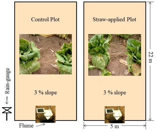
경작지에서 발생하는 비점오염원을 정량화하고 지표 피복에 의한 부유사 저감량을 평가하기 위해서, 강원도 춘천시 방동리에 위치한 경작지를 임대하여 시험포를 조성하였다. 시험포는 3%의 경사와 폭 5 m, 세로 22 m의 크기를 가지도록 하였으며 각 시험포의 사이에 폭 0.4 m와 높이 0.2 m의 둑을 조성하여 각 시험포를 구분하였다(Fig. 1). 시험포에는 대상지역에서 재배되고 있는 배추를 적용하였으며, 각 시험포의 하단에서 강우량과 지표 유출량, 부유물질 농도를 측정하였다. 경작지에서 발생하는 지표 유출량과 부유물질을 측정하기 위해서, 대조구(Control Plot)에는 배추를 60 cm × 45 cm 간격으로 파종하였으며, 지표피복을 위해 볏짚을 적용한 경작지(Straw-applied Plot)에는 대조구와 같은 간격으로 배추를 파종한 뒤, 볏짚을 토양 표면에 약 35 kg/m2을 적용하였다(Fig. 1).
대조구에서는 2010년 10월부터 2012년 10월까지 총 25회의 강우사상에 대해서 강우량, 강우지속시간, 지표 유출량, 부유사량을 측정하였으며, 볏짚을 적용한 경작지에서는 2011년에 총 14번의 강우사상에 대해서 강우량, 강우지속 시간, 지표 유출량, 부유사량을 측정하였다.
2.2. VFSMOD-w 모형을 이용한 유사량 모의 및 평가
VFSMOD-w 모형은 데스크탑 기반의 시험포단위 모형으로 시험포에서 식생여과대로의 지표 유출량과 침투 및 비점오염원의 저감 모의가 가능하다(Muñoz-Carpena et al., 1999). VFSMOD-w 모형은 시험포에서의 유출 특성을 모의하기 위해서, 강우량, 강우지속시간, CN와 같은 강우 특성 인자와, 시험포의 길이, 면적, 경사도와 같은 시험포 특성 인자, 토양의 종류, 유기물 함량, 수정범용토양유실공식(Modified Universal Soil Loss Equation; MUSLE)의 여러 인자들을 필요로 한다. 그리고 식생여과대에서의 유입량 및 비점오염원의 거동을 위해서 식생여과대의 크기, 식생의 종류 등을 입력자료로 요구한다. VFSMOD-w 모형은 시험포에서 발생한 비점오염원의 저감 모의를 위해 사용된 바 있다(Ahn et al., 2012; Park et al., 2013; Park et al., 2008).
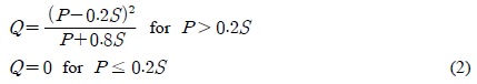
본 연구의 목적은 식생여과대에 의한 부유사 저감 모의가 아니기 때문에, VFSMOD-w 모형의 연산 과정 중에서 식생여과대에 의한 부분을 제외하고, 시험포에서의 부유사와 관련된 입력자료와 모의치만 사용하였다. VFSMOD-w 모형은 시험포에서의 지표 유출량을 Soil Conservation Service Curve Number 방법(식 (2))에 의해서 산정을 하며, 유사량을 MUSLE(식 (3))에 의해 산정한다.
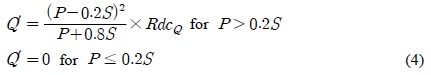
따라서 본 연구에서는 대조구에서 다수의 강우사상에 의한 실측 지표 유출량에 대해 CN을 통해 모의 지표 유출량을 보정하였으며, 실측 부유사량에 대해 수정범용토양유실 공식의 작물인자(MUSLE Crop Factor)를 통해 모의 부유사량을 보정하였다. 그리고 볏짚을 적용한 시험포에서는 지표유출량 저감에 의한 부유사량 저감이 이루어진다고 가정하였기 때문에, 대조구에서 보정된 CN를 사용하면서 VFSMOD-w모형의 소스코드를 수정하여 지표 유출량의 저감율을 반영할 수 있도록 하여(식 (4)) 볏짚이 적용된 시험포에서의 지표 유출량을 보정하였다.
여기서,

여기서,
여기서,
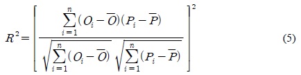
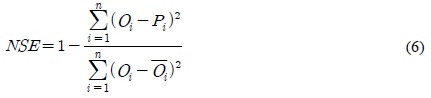
본 연구의 목적은 볏짚을 이용한 지표피복에 의한 부유사량 저감 효과를 지표 유출량 저감을 통해 평가하는 데에 있다. 그러므로 대조구에서의 실측 지표 유출량을 CN과 범용토양유실량 공식의 작물인자(USLE C)를 통해 모의 지표 유출량을 보정한 후, 볏짚을 적용한 시험포에서의 실측 지표 유출량과 식 (4)의 지표피복에 의한 유출심 저감율(%, RdcQ)을 이용하여 모의 지표 유출량을 보정하였다. 모의지표 유출량과 부유사량은 실측 지표 유출량과 부유사량에 대한 결정계수(R2, 식 (5))와 Nash-Sutcliffe Efficiency (NSE, 식 (6))에 의해 평가되었다.

여기서,
여기서,
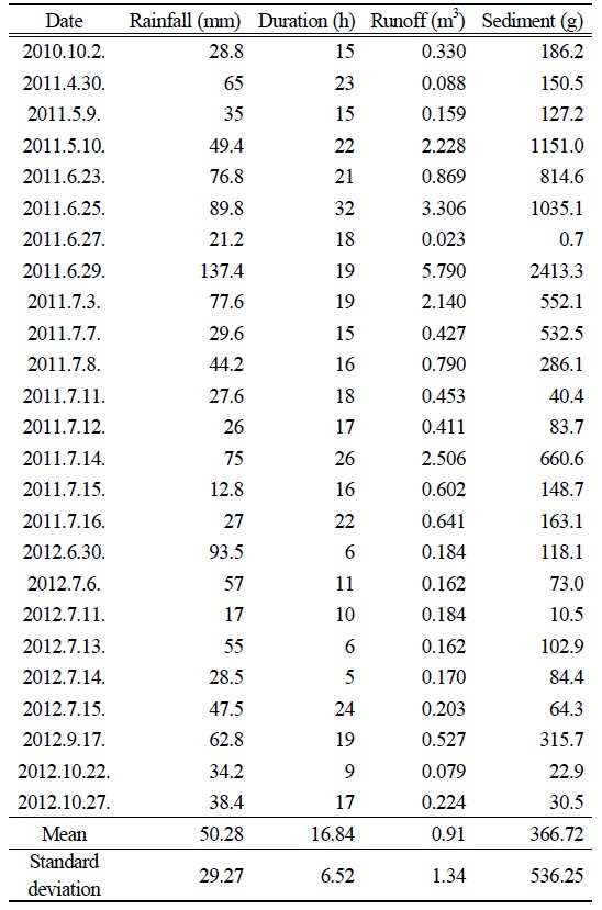
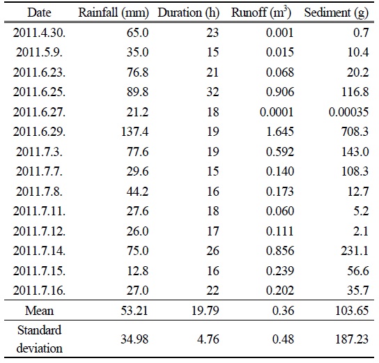
대조구와 볏짚이 적용된 시험포에서 강우량, 강우 지속시간, 지표 유출량, 부유사량이 측정이 되었다. 대조구에서는 2010년 10월부터 2012년 10월까지 총 25회의 측정이 이루어졌으며, 기간 내 최대 강우량인 137.4 mm (2011년 6월 29일)에 대해 최대 지표 유출량인 5.790 m3과 최대 부유사량인 2413.3 g이 측정되었다(Table 1). 그리고 지표 유출량과 부유사량의 결정계수(Coefficient of Determination, R2)(식 (5))가 0.89로 나타났다. 즉, 지표 유출량과 부유사량이 높은 상관관계를 보였다(Fig. 2).
[Table 1.] Measured runoff and sediment for 25 storm events at the control plot

Measured runoff and sediment for 25 storm events at the control plot
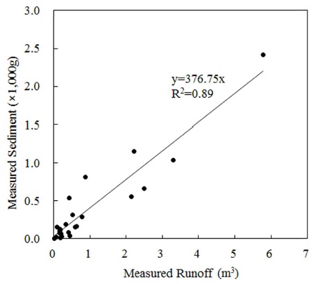
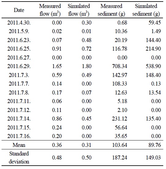
볏짚이 적용된 시험포에서는 2011년 4월부터 2011년 7월까지 총 14회의 측정이 이루어졌으며, 대조구에서와 같이 기간 내 최대 강우량인 137.4 mm (2011년 6월 29일)에 최대 지표 유출량인 1.645 m3과 최대 부유사량인 708.3 g이 측정되었다(Table 2). 대조구에서와 같이, 볏짚이 적용된 시험포에서의 지표 유출량과 부유사량의 결정계수는 0.85로 높게 나타났다(Fig. 3).
[Table 2.] Measured runoff and sediment for 14 storm events at the straw-applied plot
Measured runoff and sediment for 14 storm events at the straw-applied plot
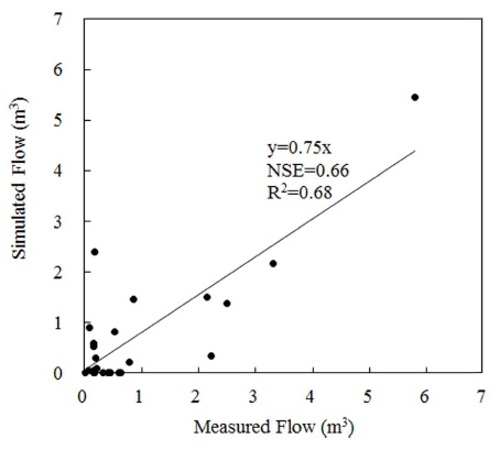
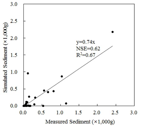
대조구에서의 25회의 강우 사상에 대한 모의 지표 유출량을 실측 지표 유출량과 비교하면서 CN을 보정하였으며 (Table 3), CN이 65일 때 NSE와 R2가 0.66과 0.68로 나타났다(Fig. 4). 또한 USLE C 인자를 이용하여 모의 부유사량을 실측 부유사량과 비교하면서 보정하였으며, USLE C 인자가 0.05일 때 NSE와 R2가 0.62와 0.67로 나타났다(Fig. 5). 즉, 모의 지표 유출량 및 부유사량의 NSE와 R2가 모두 0.6 이상으로 나타났기 때문에 보정 과정이 잘 이루어진 것으로 판단되었다.
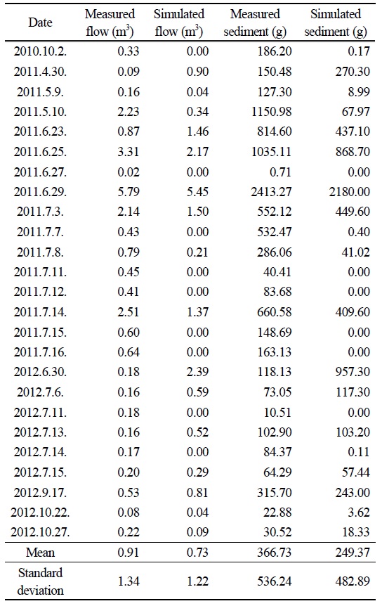
Comparison of measured and simulated values using CN and USLE C calibrations for 25 storm events at the control plot
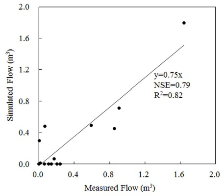
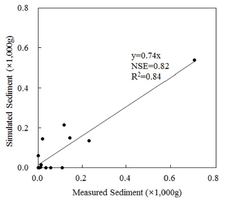
볏짚이 적용된 시험포에서의 14회의 강우 사상에 대한 모의 지표 유출량과 실측 지표 유출량을 비교하면서 RdcQ를 보정하였으며(Table 4), RdcQ가 33%일 때 NSE와 R2가 0.79와 0.82로 나타났다(Fig. 6). 그리고 이 때 실측 부유사량에 대한 모의 부유사량의 NSE와 R2는 0.82와 0.84로 나타났다(Fig. 7). 즉, 모의 지표 유출량이 잘 보정되었을 때, 부유사량과 관련된 모형의 매개변수 보정과정을 거치지 않고 실측 부유사량에 가까운 부유사량이 모의되었다. 다시 말해, 서론 부분에 언급된 선행연구(Jang et al., 2010; Lee et al., 2014)에서는 USLE P에 의해 최적관리기법에 의한 부유사량 저감을 모형에 반영하였으나, 최적관리기법에 의한 유출량 저감 효과가 수문 모형에 반영이 되면 동시에 최적관리기법에 의한 유사량 저감이 수문모형에 반영될 수 있는 것으로 나타났다.
Comparison of measured and simulated values using RdcQ calibration for 14 storm events at the control plot
2010년 10월부터 2012년 10월까지 총 25회의 강우사상에 대해서, 대조구와 실험구에서 모두 지표 유출량과 부유사량은 상관관계가 있는 것으로 나타났다. 즉, 지표 유출량이 증가할 때 부유사량이 증가하였으며, 반대로 지표 유출량을 감소시킬 경우 부유사량을 감소하였다. 볏짚으로 지표를 피복할 경우, 강우 시 지표의 교란을 방지하기 때문에 침투량을 증가시키고 지표 유출량을 감소시킨다. 그리고 감소된 지표 유출량에 의해 적은 양의 부유사량이 발생한다. 따라서 수문 모형을 이용할 때 이러한 과정을 고려할 필요가 있는 것으로 생각된다.
수문 모형에는 부유사량에 관련된 매개변수가 존재하며, 볏짚에 의한 부유사 저감량을 보정하기 위해서 매개변수의 보정이 필요할 것으로 기대되었다. 그러나 지표 유출량에 대한 보정이 이루어졌을 때, 부유사량에 관련된 수문 모형의 매개변수의 보정과정이 필요 없이 모의 부유사량이 실측 부유사량에 근사하였다. 다시 말해, 시험포에서의 수문거동을 모형에 잘 반영할 필요가 있는 것으로 생각된다.
본 연구의 결과는 볏짚의 지표피복에 의한 부유사량 저감을 모의하는 과정에서 지표 유출량이 33% 저감되도록 수문 모형에 반영하였을 때, 부유사량과 관련된 모형의 매개변수의 보정과정을 거치지 않고 실측 부유사량과 높은 상관관계를 보이는 부유사량이 모의되는 것으로 나타났다. 다시 말해, 기존의 몇몇 연구에서는 유출량에 대한 반영이 이루어지지 않고 최적관리기법에 의한 유사량 저감효과가 이루어졌으나, 수문모형 내에서 부유사량 모의 과정이 유출량과 관계가 된다면 최적관리기법에 의한 유출량 저감 효과가 먼저 반영이 될 필요가 있는 것으로 생각된다.
본 연구 결과에서는 수문모형에서 볏짚에 의한 유출량 저감율을 33%로 하였을 때 수문모형에 의한 모의치가 실측치에 가까운 것으로 나타났다. 그러나 본 연구의 목적은 부유사 저감을 위한 최적관리기법의 수문모형 적용 방법을 제안하는 것이며, 다른 수문모형에 적용할 때에는 본 연구결과의 유출량 저감율에 대한 검증이 필요할 것으로 생각된다. 또한 본 연구 수행 기간 동안에는 태풍과 같은 큰 강우사상이 발생하지 않았기 때문에, 태풍 등을 포함할 가능성이 있는 장기간에 대한 최적관리기법에 의한 유사 저감 효과에 대해서는 모의 결과가 달라질 수 있다.